About Voie Georges-Pompidou
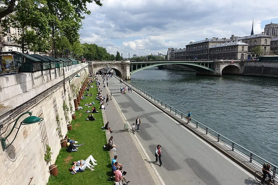
The Voie Georges-Pompidou is a 13-kilometer expressway that runs along the Right Bank of the Seine in Paris. Named after the former president Georges Pompidou, who inaugurated the project in 1967 as prime minister, it was part of a sweeping plan to adapt the capital to automobile traffic. The route runs partly right along the river, partly along the higher embankment roads, and partly underground. One of the few sections of the so-called Pompidou Plan that was actually built, it long remained a one- or two-lane access road with a 50 km/h speed limit and few traffic lights, running mainly in an east–west direction.
In recent years, however, the character of this road has changed fundamentally. Since 2016, the section between the Tuileries Tunnel and the Quai Henri-IV has been closed to car traffic and converted into a pedestrian zone. The move was part of a larger concept aimed at upgrading the historic riverbanks and strengthening the ecological continuity of the Seine. The area is now integrated into the Rives-de-Seine park, which also includes the Left Bank. While the western stretch of the riverbank is still used by a bike path, the eastern part now invites you to take a stroll.
The conversion into a promenade was accompanied by political and legal debate, as opponents feared that car traffic would simply shift to surrounding streets. Nevertheless, the city administration upheld the traffic ban on the grounds of protecting the World Heritage site, in order to preserve the authenticity of the riverside landscape. Today, visitors to this stretch find a quiet, green oasis in the heart of the city, with open views of the Seine and a striking contrast to the busy downtown streets.
At a glance
- Category
- Sight › Historic sites
- Rating
- no reviews yet · write a review
- Address
- —
Paris, France - District
- 1st Arrondissement
- Phone
- —
- Website
- fr.wikipedia.org
- —
- Coordinates
- 48.86366° N · 2.32171° E
- Data quality
- confidence 0.81
- Identifier
- ID a7b290ab-278…
Location & surroundings
Toggle layersFAQ about Voie Georges-Pompidou
quick answersWhat is the Voie Georges-Pompidou in Paris?
The Voie Georges-Pompidou is an expressway about 13 kilometers (8 miles) long that runs along the Right Bank of the Seine in Paris. It is named after Georges Pompidou, who inaugurated the project in 1967 as prime minister, and was part of the so-called Pompidou Plan, which aimed to adapt the capital to car traffic. The route runs partly right along the river, partly along elevated riverside roads, and partly underground, mostly in an east-west direction.
Can you walk along the Voie Georges-Pompidou?
Yes, part of the Voie Georges-Pompidou in Paris is now a pedestrian zone. Since 2016, the stretch between the Tuileries Tunnel and the Quai Henri-IV has been closed to cars and is part of the Rives-de-Seine park, which also includes the Left Bank of the Seine. The eastern section invites you to stroll with views of the Seine, while the western stretch of the riverbank is still used by a bike path.
Why was the Voie Georges-Pompidou closed to car traffic?
The closure of a section of the Voie Georges-Pompidou in Paris was meant to enhance the historic riverbanks and strengthen the ecological continuity of the Seine. The city administration justified the traffic ban by citing the protection of the World Heritage site and the authenticity of the riverside landscape. The conversion was accompanied by political and legal debate, as opponents feared that car traffic would shift to surrounding streets.
What can you see around the Voie Georges-Pompidou?
Several well-known sights are located right near the Voie Georges-Pompidou in the 1st arrondissement of Paris. According to travelguide195, the Musée de l'Orangerie is only about 70 meters (230 feet) away, and the Pont tournant des Tuileries is about 170 meters (560 feet) away. About 210 to 220 meters (690 to 720 feet) away, you'll find the Place de la Concorde with the Luxor Obelisk.
Are there restaurants near the Voie Georges-Pompidou?
Yes, there is a wide range of dining options around the Voie Georges-Pompidou in Paris. travelguide195 lists about 81 restaurants within 500 meters (about 1,640 feet) of this stretch on the Right Bank of the Seine in the 1st arrondissement.
Ratings & comments
none yetNear Voie Georges-Pompidou
closest 5 per category · 2 kmSights
Restaurants
Museums
Hotels
More:Historic sites in Paris (1,524)Sights in 1st Arrondissement (131)All sights in Paris (1,859)
300 places within 2 km loaded.
You need a free account to leave reviews and photos – that keeps comments genuine and lets you edit them later.