About Erith
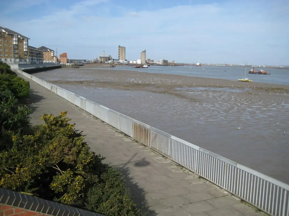
Erith is a district in southeast London, about 13 miles (21 km) east of Charing Cross. Since the creation of Greater London in 1965, it has belonged to the London Borough of Bexley; before that, it lay within the historic county of Kent. Geographically, the area sits on the south bank of the Thames, northeast of Bexleyheath and northwest of Dartford. The landscape blends urban development with natural elements, as salt marshes and industrial areas lie side by side along the riverbanks. Erith has the longest pier in all of London, a reminder of its historic importance as a port town. The area is well connected to the transportation network, with rail links to Kent and central London as well as a dual carriageway that provides a direct connection to the Thamesmead housing area.
The history of the area stretches back to prehistoric times. Archaeological finds suggest that in the Neolithic period the area was covered by a dense forest of oak, yew and other trees, which partly turned into marshland during the Bronze Age. Traces of a significant settlement or farmstead from the first century A.D. were discovered at the site of the former Erith School. After the collapse of Roman rule in the early fifth century, the region was settled by Anglo-Saxon immigrants. The name Erith derives from the Anglo-Saxon "Ærre hyðe," meaning "old harbor." It is likely that a church already stood on the site of today's St John the Baptist's Church at that time, with the early settlement forming around it.
The first written mention of the place appears in a Latin charter from the year 695, which documents a land transfer by the Bishop of the East Saxons. In the Domesday Book of 1086, the area is recorded under the name Lesnes or Lessness. After the Norman Conquest, the land passed to Bishop Odo. In the 14th century, Erith was granted the right to hold a market every Thursday, though by the 18th century it was considered to have ceased. Erith owes its real heyday as an important place to the Thames. Until the 1850s it was essentially a small river port, which gained significance when King Henry VIII decided to establish a naval dockyard there. The famous warship Henri Grace à Dieu was fitted out at this dockyard in 1515. For a long time, the area served as a popular anchorage where ships offloaded cargo to reduce their weight before moving into the shallower stretches of the river.
The 19th century brought a period of change to Erith. In 1849 the town briefly served as a river resort, attracting day-trippers with a pier, a hotel and an arboretum with pleasure gardens. Industrial development picked up sharply from the 1860s, when the Erith Iron Works was founded. A tragic event was the gunpowder explosion of 1864, which breached the river wall; a flood disaster was narrowly averted thanks to the efforts of workers and soldiers. Later, the area was shaped by cable works and armaments production, particularly by the company Vickers, which played a central role in manufacturing weapons and ammunition during World War I.
In the 20th century, Erith first became an Urban District under the Local Government Act of 1894 and then a Municipal Borough in 1938. An important cultural building is the town's first library, which opened in 1906 and was funded by the philanthropist Andrew Carnegie. During World War II, the town suffered heavy bomb damage, which, together with the decline of local trade, led to a comprehensive redevelopment in the 1960s. The old town was demolished and replaced with modern residential and commercial buildings, and many Victorian structures were lost. Only a few historic structures, such as St John's Church and the White Hart Inn, survived.
Since the late 1990s, Erith has been going through a period of regeneration as part of the Thames Gateway project. The focus is on developing the waterfront and the town center. Since 2000, private developers have built numerous new apartments along the river. Plans call for mixed use, with new commercial space and additional housing. One special project is the restoration of the former library building into new community facilities, for which funding from the National Lottery Fund was approved in 2020. In addition, the former quarry site west of the center is being transformed into a new residential area with a primary school and a supermarket.
Today, Erith offers visitors a mix of historic heritage and modern infrastructure. Riverside Gardens on the banks of the Thames is a popular spot for relaxation and the venue for the annual Erith Riverside Festival. The town is also a starting point for popular walking routes such as the London Outer Orbital Path and the Green Chain Walk. Culturally, the Erith Playhouse Theatre, the largest theater in the Borough of Bexley, is a major draw. For sports, you can visit the Erith Leisure Centre with its swimming pool or the David Ives Stadium, home of the Bexley Athletic Club. The Erith Rowing Club and the Erith Yacht Club offer opportunities for water sports on the riverfront.
Erith's population is diverse and has changed considerably in recent decades. While White British residents made up 89 percent in 1991, that figure had fallen to 62 percent by the 2011 census. The second-largest ethnic group is Black Africans, at 14 percent. The town is also the birthplace or home of several well-known figures in the arts, sports and politics, including the jazz pianist Ronnie Aldrich, the poet Wendy Cope and the artist John Downton. Despite its industrial past and urban restructuring, Erith retains its character as a lively riverside town that combines history and modernity.
At a glance
- Category
- Sight › Historic sites
- Rating
- no reviews yet · write a review
- Address
- —
London, United Kingdom - District
- London Borough of Bexley
- Phone
- +441322449744
- Website
- —
- —
- Coordinates
- 51.47630° N · 0.16810° E
- Data quality
- confidence 0.83
- Identifier
- ID 721f7d69-908…
Location & surroundings
Toggle layersRatings & comments
none yetNear Erith
closest 5 per category · 2 kmSights
Restaurants
Museums
Hotels
Cocktail bars
None within 2 km.
More:Historic sites in London (3,142)Sights in London Borough of Bexley (42)All sights in London (3,487)
77 places within 2 km loaded.
You need a free account to leave reviews and photos – that keeps comments genuine and lets you edit them later.