About Antonine Wall
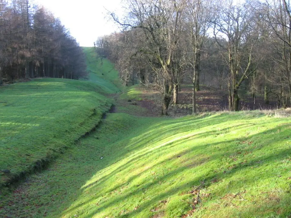
The Antonine Wall was an important Roman frontier fortification in northern Britain, found today mainly in the area around Glasgow and in Scotland's Central Belt. The second great wall system after Hadrian's Wall, which lies farther south, it served as the provisional northern boundary of the Roman Empire. Emperor Antoninus Pius had it built in the middle of the 2nd century A.D. in order to push the province of Britannia roughly 160 kilometers farther north. The structure ran across the narrowest part of the British island, from the Firth of Clyde in the west to the Firth of Forth in the east. Although the wall is less well known than its stone predecessor, it offers a fascinating glimpse into Roman military history and the Scottish landscape today.
The wall's strategic location was extremely advantageous topographically. It followed the natural ridges of the Central Lowlands, which gave defenders an excellent view to the north. The line stretched over roughly 60 kilometers, less than half the length of Hadrian's Wall. In the west, the structure began at the fort of Old Kilpatrick on the northern bank of the Clyde, while in the east it ended at Carriden near Bridgeness. Between these endpoints, the wall crossed rivers such as the Avon and the Kelvin and wound over basalt knolls and rolling hills. This route had already been identified in the 1st century by the Roman general Gnaeus Julius Agricola and still serves as the course of modern roads today, underscoring the historical importance of the corridor.
The construction of the wall differed fundamentally from that of Hadrian's Wall. Instead of massive stone walls, a timber-and-earth fortification known as the murus caespiticius was built here. The foundation consisted of unmortared rubble stone, on top of which a rampart of turf blocks was piled. This rampart was about three to four meters high and five meters wide and was crowned by a wooden walkway. On the north side lay a wide V-shaped ditch, which served as an obstacle to approach and was secured by a bank of piled-up earth. A paved military road ran parallel to the wall and allowed patrols to move troops quickly. The simple method of construction required less material and time, which made it possible to complete the work within a few years.
The wall's function lay primarily in regulating and monitoring traffic across the frontier and in collecting customs duties. It was also meant to provide protection against raids by the Caledonian tribes, who threatened Roman territory. Because the wall ran along the narrowest point of the island, the Roman army could control the area between the two firths more effectively. However, the structure was never conceived as a permanent border. The absence of heavy obstacles to approach such as palisades suggests that it was a temporary solution. The emperor's exact motives remain disputed, but it is assumed that by expanding the empire he wanted to underscore his military competence and dispel growing doubts about his rule.
The wall's history was a short one. Construction began under the governor Quintus Lollius Urbicus and was completed between 142 and 144 A.D. The core structures were finished within two years, while the full infrastructure took another twelve years. Despite its rapid construction, the wall was abandoned after only a few decades. Around 160 A.D., even before the death of Antoninus Pius, most of the troops were pulled back to Hadrian's Wall. The main reason for this withdrawal was less pressure from the Caledonian tribes than the threat on the Danube frontier from invading barbarian peoples. Not until the early 3rd century, under Emperor Septimius Severus, was the wall briefly reoccupied.
The wall was secured militarily by a tight network of forts. In all, about 19 auxiliary forts were built, spaced at regular intervals along the line. These were mostly made of timber and earth, with a few exceptions such as Castlecary and Balmuildy that had stone walls. The forts were laid out in the typical rectangular form of the mid-imperial period and were mostly oriented toward the north. Between the larger forts lay smaller milefortlets, which shortened the distance to about three kilometers and were commanded from the main camps. This structure allowed a quick response to attacks and effective surveillance of the entire frontier section.
The garrisons consisted of a force of roughly 7,000 men, made up of legionary detachments and auxiliary cohorts. The three home legions of Britain, Legio II Augusta, Legio VI Victrix, and Legio XX Valeria Victrix, took part in the construction, as building inscriptions attest. These stone tablets, known as distance slabs, were buried at the ends of the construction sections and reveal which units took part and how long each section was. One particularly elaborate tablet from the eastern section is now in the National Museum of Antiquities in Edinburgh and shows reliefs of Roman soldiers and ritual sacrificial scenes.
Over time, civilian settlements known as a vicus also grew up around the larger forts. These settlements governed themselves and were not under the direct control of the military. They served trade and the supply of the soldiers and contributed to cultural mixing. Despite the Roman presence, the Pictish and Celtic tribes living there were never permanently subdued. The traditional hillforts of the local population were cleared under Roman pressure, which led to unrest in the Lowlands. The Roman strategy of control by relocating settlements to the plains proved difficult to carry out, since the army could hardly intervene quickly from distant Hadrian's Wall.
Today the remains of the Antonine Wall can still be made out clearly in the terrain at various places around Glasgow. The earthen ramparts and ditches are especially visible in the areas of Bearsden, Kirkintilloch, Twechar, Croy, Falkirk, and Polmont north of Glasgow. These sections give visitors the chance to explore the historic landscape and imagine the Roman presence. Since 2008, the wall has been a UNESCO World Heritage Site as part of the European limes, protected together with Hadrian's Wall and the Upper German-Raetian Limes.
For visitors, the Antonine Wall is a place of discovery where history and nature merge. The hiking trails along the former frontier fortification let you experience the strategic location and the lay of the land that the Roman engineers took into account in their planning. The well-preserved sections offer an impressive view of the topography that made the wall so advantageous. In addition, the archaeological finds, such as the building inscriptions and the remains of the forts, offer deep insights into the life and organization of the Roman army in Britain. The Antonine Wall is thus not only a historic monument but also a living part of the Scottish cultural landscape that invites reflection on the past.
At a glance
- Category
- Sight › Historic sites
- Rating
- no reviews yet · write a review
- Address
G65 9SG Glasgow, United Kingdom- Phone
- —
- Website
- ro.wikipedia.org
- —
- Coordinates
- 55.96719° N · -4.06703° E
- Data quality
- confidence 0.70
- Identifier
- ID 74459b11-17b…
Location & surroundings
Toggle layersFAQ about Antonine Wall
quick answersWhat is the Antonine Wall near Glasgow?
The Antonine Wall is a Roman frontier fortification in northern Britain, with remains today found mainly in the area around Glasgow and in Scotland's Central Belt. Emperor Antoninus Pius had it built in the mid-2nd century AD to extend the province of Britannia roughly 160 kilometers (about 100 miles) to the north. After Hadrian's Wall farther south, it was the second great wall complex and served as the provisional northern boundary of the Roman Empire.
How long is the Antonine Wall and where does it run?
The Antonine Wall near Glasgow stretched about 60 kilometers (roughly 37 miles) across the narrowest point of the British island, from the Firth of Clyde in the west to the Firth of Forth in the east. In the west it began at the fort of Old Kilpatrick on the north bank of the Clyde, and in the east it ended at Carriden near Bridgeness. Along the way it crossed rivers such as the Avon and the Kelvin and followed the ridges of the Central Lowlands, which offered good views to the north.
How was the Antonine Wall built, and how does it differ from Hadrian's Wall?
Unlike the stone Hadrian's Wall, the Antonine Wall near Glasgow was a timber-and-earth fortification, a so-called murus caespiticius. A rampart of turf blocks, roughly three to four meters (10 to 13 feet) high and five meters (16 feet) wide, sat on a foundation of unmortared rubble stone and was topped by a wooden walkway. A wide V-shaped ditch protected the north side, and a fortified military road ran parallel to the wall for patrols. At about 60 kilometers, it was also less than half as long as Hadrian's Wall.
What was the purpose of the Antonine Wall?
The Antonine Wall in Scotland served mainly to regulate and monitor movement across the frontier and to collect customs duties. It was also meant to provide protection against raids by the Caledonian tribes. It was never intended as a permanent border: the lack of heavy obstacles to approach, such as palisades, points to a temporary solution.
What can you see around the Antonine Wall near Glasgow?
Within a one-kilometer radius, travelguide195 lists the Bar Hill Antonine Wall Fort, a Roman fort on the Antonine Wall. It lies about 980 meters from the point on the wall recorded in the database. There you can get a closer look at the military infrastructure of the Roman northern frontier near Glasgow.
Ratings & comments
none yetNear Antonine Wall
closest 5 per category · 2 kmSights
Restaurants
Museums
None within 2 km.
Hotels
Cocktail bars
None within 2 km.
More:Historic sites in Glasgow (203)All sights in Glasgow (257)
27 places within 2 km loaded.
You need a free account to leave reviews and photos – that keeps comments genuine and lets you edit them later.