About Caldera del Rey
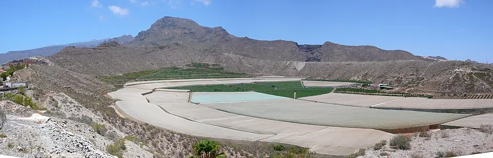
The Caldera del Rey in southern Tenerife is a unique geological natural monument and one of the island's best examples of phreatomagmatic volcanism. This broad caldera was formed by the explosive contact of magma with water, producing mainly salic (silica-rich) materials, while older basaltic rock of the Adeje Massif occurs to the north. The protected area covers just under 109 hectares (about 270 acres) and, despite its modest height, offers an impressive volcanic landscape. The vegetation is naturally sparse, with tabaiba trees on the less altered north slope, while the interior and the southwest side are dominated by banana plantations and ornamental plants. Here you can also spot rare bird species such as the desert buzzard and the trumpeter finch. A special part of the cultural heritage is the cave dwellings carved into the toba (volcanic tuff), once home to agricultural workers. Today only a few families still live in these troglodyte homes, which stand as a testament to local history. The area was declared a nature park in 1987 and a natural monument in 1994, though protecting it from vandalism remains an ongoing challenge.
At a glance
- Category
- Sight › Historic sites
- Rating
- no reviews yet · write a review
- Address
- —
Adeje, Spain - Phone
- +34672373832
- Website
- www.tenerifehorses.com
- —
- Coordinates
- 28.08278° N · -16.71472° E
- Data quality
- confidence 0.82
- Identifier
- ID 9e7eba2d-063…
Location & surroundings
Toggle layersRatings & comments
none yetNear Caldera del Rey
closest 5 per category · 2 kmSights
Restaurants
Hotels
More:Historic sites in Adeje (62)All sights in Adeje (64)
164 places within 2 km loaded.
You need a free account to leave reviews and photos – that keeps comments genuine and lets you edit them later.