About Platforma Tâmpa
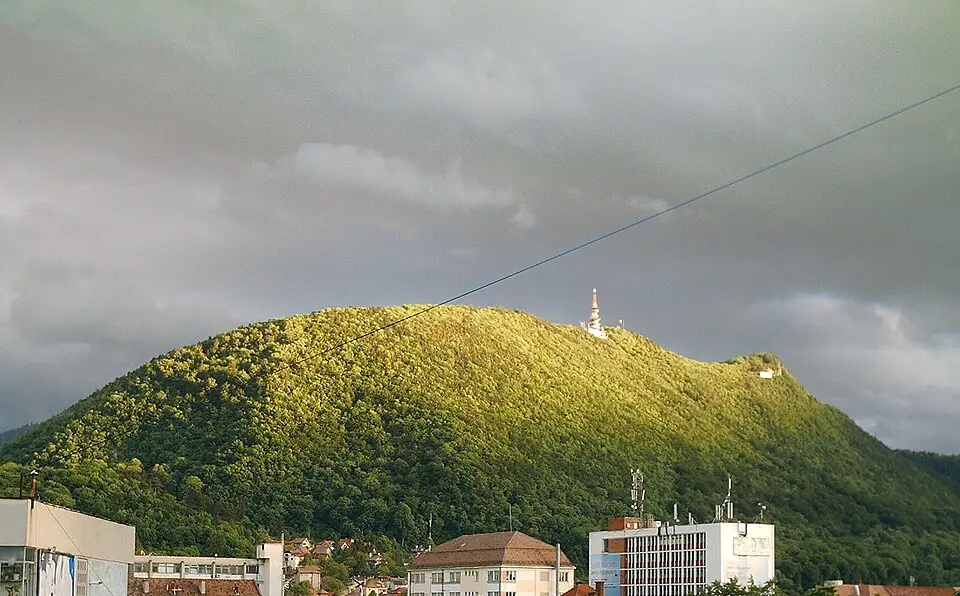
Mount Tâmpa is a striking mountain in the southern part of the Eastern Carpathians, almost entirely surrounded by the Romanian city of Brașov. At roughly 960 meters (about 3,150 feet), this limestone massif rises nearly 400 meters above the city and holds a large nature reserve, prized for rare animal and plant species such as bears, a wide variety of butterflies, and specific grass species. You can reach the summit by several routes, including a historic switchback trail with 25 turns, built in 1837, or the so-called Knights' Road, which dates back to the days of the medieval fortress. A modern cable car links the base station near the Casa Pădurarului with the summit area in under three minutes, making the ascent comfortable even for less athletic visitors.
The mountain's history is deeply rooted in the past. The Dacians left traces of a pagan cult here, and in the Middle Ages the fortress of Brașovia was built between the summit and the ridge. This stronghold was one of the seven fortified towns that gave the region its name, Transylvania (German: Siebenbürgen, "Seven Castles"), and in the 14th and 15th centuries it served several times as a refuge for the people of Brașov during Tatar and Ottoman attacks. Because the fortress was so well protected strategically that it was never taken by force, the townspeople decided, after recapturing it, to tear it down and use its stones to fortify the town in the valley. Today only foundations and small towers recall this military past, while other historic sites, such as the ruins of a Catholic chapel from the early 18th century and the remains of an aqueduct from 1891, document the many uses of the mountain over time.
From the summit, you get a spectacular panoramic view over the whole city of Brașov; on clear days you can even see the surrounding Burzenland (Țara Bârsei). The summit area now has a restaurant with a large glass front that opens up views of the city, as well as a television tower structure. One special feature is the illuminated flagpole, which lights up the sky with laser beams in the evening hours. The mountain also bears traces of various political eras, including the base of a former monument to the Hungarian prince Árpád, which was blown up during World War I, and a sequence of letters formed from spruce trees, planted during the communist era and now only partly legible.
At a glance
- Category
- Sight › Historic sites
- Rating
- no reviews yet · write a review
- Address
- Vârful Tâmpa
Brasov, Romania - Phone
- —
- Website
- romaniatourism.info
- —
- Coordinates
- 45.63456° N · 25.59316° E
- Data quality
- confidence 0.92
- Identifier
- ID 08ea9121-c48…
Location & surroundings
Toggle layersRatings & comments
none yetNear Platforma Tâmpa
closest 5 per category · 2 kmSights
Restaurants
Museums
Hotels
More:Historic sites in Brasov (123)All sights in Brasov (137)
191 places within 2 km loaded.
You need a free account to leave reviews and photos – that keeps comments genuine and lets you edit them later.