About Bridgewater Bridge
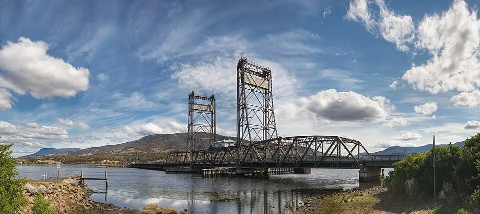
The Bridgewater Bridge in Tasmania is a historic steel lift bridge spanning the Derwent River in the southeast of the state. It lies along the Midland Highway and connects the towns of Granton and Bridgewater. The structure consists of the lift bridge itself, near the north bank, and a long causeway linking the bridge to the shore. The structure carries two lanes of the main road, a single-track railway line to Launceston, and a footpath alongside the lift span. As part of the main transport route between Hobart and Launceston, raising the bridge can cause significant traffic delays.
The history of the river crossing dates back to 1829, when Lieutenant Governor George Arthur ordered its construction to improve access to the central farmland. The causeway was built by 200 convicts using only their bare hands and simple tools, moving millions of tons of earth. A viaduct was originally planned, but it was changed to a causeway. The first bridge followed in 1849, a swing bridge that was modified several times and finally replaced in the early 20th century. Remains of the old pivot bearings are still visible today to the left of the current bridge. Construction of the current steel lift bridge began in 1939 and was completed in 1946, after World War II. It is considered the largest of its kind in Australia and was designed to last a hundred years.
Visitors can experience the bridge as a striking landmark of the region. A small bridge-keeper's hut houses the machinery for raising and lowering the structure. Until the 1980s, the span had to be opened frequently because paper products were transported by ship; today this rarely happens. The bridge has also faced technical challenges, such as a fatigue fracture in the counterweight cables in 2006, which led to a temporary closure. Because of its high heritage value and historical significance, the bridge is cherished as a landmark. Plans call for it to be replaced as part of the upgrade of the Midland Highway, while the old structure is to be retained for local road and rail traffic as well as pedestrians.
At a glance
- Category
- Sight › Historic sites
- Rating
- no reviews yet · write a review
- Address
- Midland Hwy
7030 Hobart, Australia - Phone
- —
- Website
- en.wikipedia.org
- —
- Coordinates
- -42.74083° N · 147.22528° E
- Data quality
- confidence 0.89
- Identifier
- ID 7a6d8aa1-3e0…
Location & surroundings
Toggle layersRatings & comments
none yetNear Bridgewater Bridge
closest 5 per category · 2 kmSights
None within 2 km.
Museums
None within 2 km.
Cocktail bars
None within 2 km.
More:Historic sites in Hobart (130)All sights in Hobart (139)
11 places within 2 km loaded.
Don't miss in Hobart
All sights Historic sites01
Mount Pleasant Radio Observatory
Denholms Rd · Hobart○ Website○ Phone Historic sites02
Salamanca Place
Salamanca Pl · Hobart● Website● Phone Monuments03
The Tasman Fountain
Gladstone St · Hobart● Website○ Phone Historic sites04
You need a free account to leave reviews and photos – that keeps comments genuine and lets you edit them later.